

Alabama Snow Update
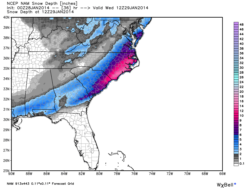
Here is a look at the new 00Z NAM run just in….
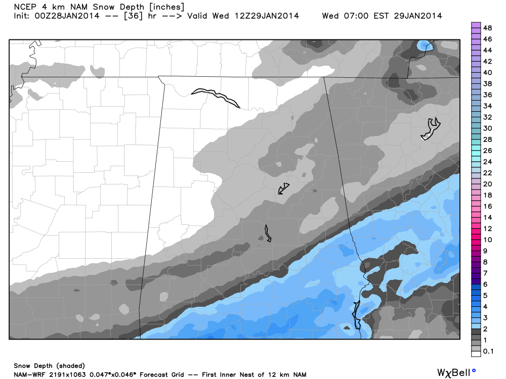
And, a close look at the high resolution (4km NAM) output…
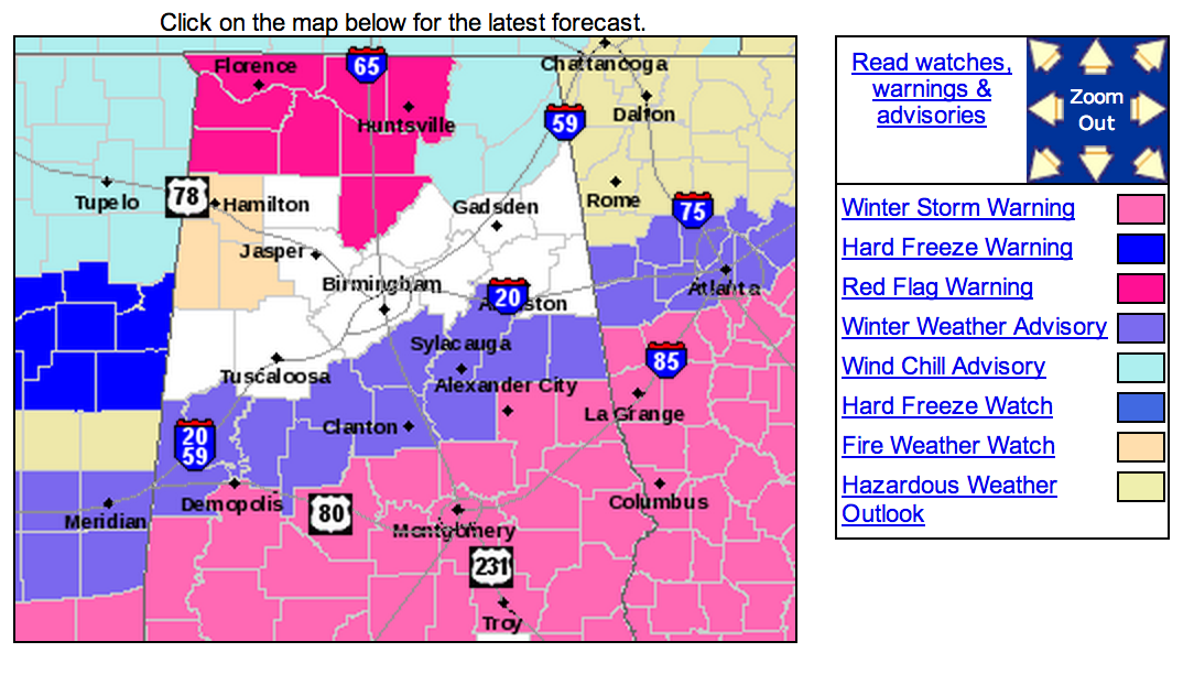
There are no change in the warnings and advisories, other than three counties added to the “Winter Weather Advisory”…. Bibb, Shelby, and Talladega. This is a slight northward extension, but no major change.
We have adjusted our snow accumulation forecast ever so slightly…
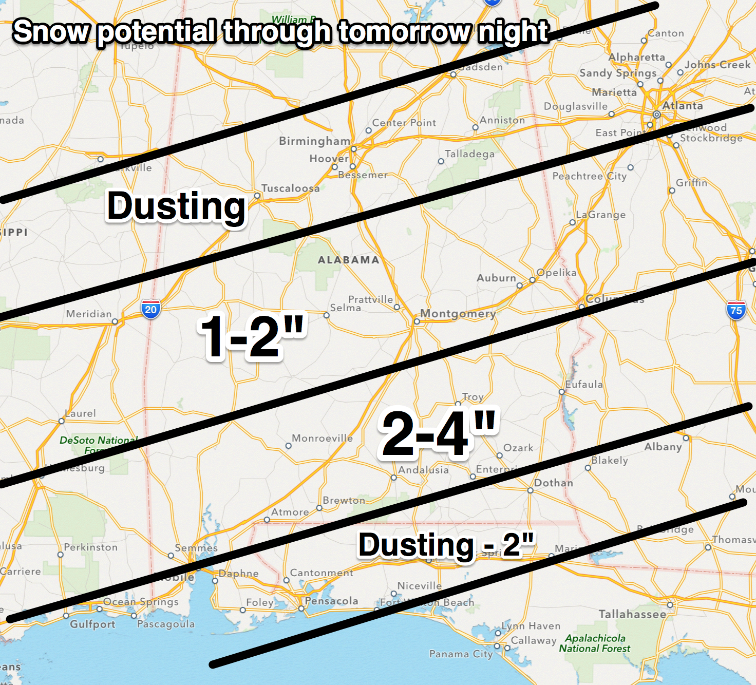
Here are the highlights of what to expect tomorrow…
*ALL of Alabama will be very cold. The northern quarter of the state, north of U.S. 278, won’t get out of the 20s. The high for Birmingham, Tuscaloosa, Anniston, and Gadsden will be only in the low to mid 30s.
*Snow will begin tomorrow morning over North Alabama, but it will be light. There is a good chance you will see snow in Birmingham, Tuscaloosa, Anniston, and Gadsden, but it should be light, and significant accumulation is not expected. No major travel issues are expected in these areas despite the snow.
*The chance of accumulating snow begins generally along and south of a line from Livingston to Eutaw to Greensboro to Centreville to Alabaster to Talladega to Ranburne. Some light accumulation is possible (1 inch of less) in the counties under a Winter Weather Advisory. These counties are Sumter, Greene, Hale, Bibb, Shelby, Talladega, Clay, Randolph, Perry, Chilton, and Coosa. Some minor travel issues are possible, if you live or travel in these counties, we don’t expect widespread road problems, but icy spots are very possible.
*The major snow/ice threat is along and south of U.S. 80, or south of a line from Demopolis to Selma to Montgomery to Opelika. Some communities over South Alabama could see 2 to 4 inches of snow. The heavier snow will come across South Alabama from around 12:00 noon tomorrow through 10:00 p.m.
*Near the coast, the precipitation will begin in places like Mobile, Gulf Shores, and Pensacola as rain and sleet. This will change to freezing rain tomorrow evening, and snow tomorrow night. Mobile and Pensacola could see around one inch of snow, but freezing rain and ice is the bigger threat for these coastal cities.
*Travel will be greatly impacted across the southern half of Alabama. Bridges and overpasses will be icy and dangerous, and some black top roads will become slick as well where heavier snow falls. The I-10 Bayway between Mobile and Spanish Fort will become very icy tomorrow night.
Governor Robert Bentley has declared Alabama in a “state of emergency” beginning tomorrow at 6:00 a.m. National Guard units are on standby to help if needed, and ALDOT crews are ready to work on roads.
We stress the biggest snow/ice problems will come over the southern half of Alabama tomorrow, but some snow is likely up through North/Central Alabama. It just won’t be too heavy and significant accumulation is not expected other than a dusting.
Skill in forecasting winter weather events in South Alabama is not especially high simply because we don’t have much experience and too many analogs. Be ready for some surprises, and stay tuned for updates…
Category: Alabama's Weather
About the Author (Author Profile)
James Spann is one of the most recognized and trusted television meteorologists in the industry. He holds the AMS CCM designation and television seals from the AMS and NWA. He is a past winner of the Broadcast Meteorologist of the Year from both professional organizations.Subscribe
If you enjoyed this article, subscribe to receive more just like it.


